Coorong, the Accommodation, Hotels, Tours & Information
Places nearby Coorong, the
- Aldinga Beach
- Ashbourne
- Back Valley
- Blewitt Springs
- Bull Creek
- Cape Jervis
- Carrickalinga
- Clare Valley
- Clayton
- Currency Creek
- Delamere
- Encounter Bay
- Finniss
- Goolwa
- Goolwa Beach
- Goolwa North
- Goolwa South
- Hartley
- Hayborough
- Hindmarsh Island
- Hope Forest
- Inman Valley
- Kuitpo
- Kuitpo Colony
- Langhorne Creek
- Maslin Beach
- McLaren Vale
- Mccracken
- Mclaren Flat
- Meadows
- Middleton
- Milang
- Mount Compass
- Myponga
- Narrung
- Normanville
- Pages Flat
- Parawa
- Point Macleay
- Port Elliot
- Port Willunga
- Prospect Hill
- Rapid Bay
- Second Valley
- Sellicks
- Sellicks Beach
- Sellicks Hill
- Silver Sands
- Strathalbyn
- Tooperang
- Victor Harbor
- Victor Harbour
- Waitpinga
- Willunga
- Wirrina Cove
- Woodchester
- Yankalilla
- Yilki
- Yundi
Coorong, the
You can start a coastal tour of the Limestone Coast region at Meningie on the southeastern shore of Lake Albert.
THE COORONG NATIONAL PARK This park is of international significance as a breeding ground for migratory birds. Beginning just south east of Meningie, it sweeps almost 130 kilometres along the coast, its width never exceeding 3 kilometres.
Sand dunes separate the shallow lagoon waters of The Coorong from the Southern Ocean. This narrow stretch of water supports hundreds of bird species, among them migratory birds from as far afield as Siberia, and some endangered Australian species. The wetlands here are listed as internationally significant and Australia is a signatory to international agreements for the protection of migratory species using the area.
Just inside the northern end of the park there is a red caravan offering fresh Coorong mullet (yellow eye mullet), flounder and mulloway for sale when the catch is in. The mullet is a catch much preferred by fishermen who know the salty waters of the Coorong produces the tastiest results. JACK'S POINT PELICAN OBSERVATORY The Coorong is home to the world's largest breeding colony of pelicans. Jack's Point Pelican Observatory is about 10 minutes drive south of the park boundary and a quick stop of 20 minutes is all you need to walk to the viewing shelter across from the breeding islands. Signs along the gravelled walk identify the key vegetation of the region. The shelter has a very basic set of binoculars but bring your own to view the birds clearly. They can also be watched from boats but there is a 140-metre boundary requested around the islands for the safety and comfort of the birds.
SALT CREEK At Salt Creek, 59 kilometres further southeast from Meningie along the Princes Highway, the Friends of the Coorong have assisted the National Parks and Wildlife Service to develop the Lakes Nature Trail, two-kilometres in from the entrance from the highway. This is an easy three-kilometre, one-hour walking circuit that includes frequent seating.
The walk skirts Pipeclay Lake which displays geology in action through the formation of carbonate sediments into limestone and dolomite, then cuts across a gently sloped sand dune-covered with mallee, tea-tree and yakkas, to the salt lake. Loop Road (unsealed but good driving) takes you from the Nature Trail car park back to the Princes Highway further down the Coorong.
Other walk options here include the Ngrugie Ngoppun ('good walk' in Ngarrindjeri language), a one-hour walk circling Salt Creek that includes excellent opportunities for bird watching and photography. There is also a longer walk. There are toilets in the car park adjacent to the walking trail.
CHINAMAN'S WELL Well worth a look-see, 16 kilometres south of Salt Creek (about five minutes drive south from where the Loop Road rejoins the highway and just above 42 Mile Crossing). A short walk from the car park here will bring you to the ruins of the old Eating House, a four-room stopover on the Adelaide to Melbourne stagecoach route built in 1864.
Many Chinese landed illegally at the towns along the Coorong and walked overland to work in the Victorian goldmines, thus avoiding the hefty ten pound poll tax but the spot gets its name from other Chinese settlers, who sold fresh food and water to their travelling countrymen. The well was built from local limestone and sandstone in 1856 and is possibly the only surviving example of its type.
Great deals on hotels in Fleurieu Peninsula...
|
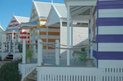
Beach Huts Middleton - Middleton 
From: A$240 More Info... |
|
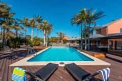
McLaren Vale Motel - McLaren Vale  
From: A$307 More Info... |
Coorong, the: Travel Tips
Meningie is 153 kilometres south east of Adelaide and is considered the gateway to The Coorong. The entrance to The Coorong National Park is a 15-minute drive from Meningie.
Coorong, the Map
 Multiple Hotels
  Hotel
Hotel 

