Kalangadoo Accommodation, Hotels, Tours & Information
Places nearby Kalangadoo
- Avenue
- Beachport
- Binnum
- Bordertown
- Bray
- Cannawigara
- Cape Jaffa
- Carpenter Rocks
- Comaum
- Compton
- Coonawarra
- Frances
- Glencoe
- Glencoe West
- Glenroy
- Greenways
- Hatherleigh
- Hynam
- Keith
- Kingston S.E.
- Kingston Se
- Kongorong
- Kybybolite
- Lucindale
- Meningie
- Mil Lel
- Millicent
- Moorak
- Mount Burr
- Mount Gambier
- Mount Gambier East
- Mount Gambier West
- Mount Schank
- Mundulla
- Nangwarry
- Naracoorte
- Naracoorte North
- O B Flat
- Padthaway
- Penola
- Policemans Point
- Port MacDonnell
- Rendelsham
- Robe
- Salt Creek
- Sherwood
- Southend
- Struan
- Tantanoola
- Tarpeena
- Wandilo
- Western Flat
- Wolseley
- Woods Well
- Wrattonbully
- Yahl
Kalangadoo
About 50 km north of Mount Gambier in the heart of red gum country, the Kalangadoo district has been at the centre of a strong pastoral industry for more than 150 years. When the first farmers moved their stock into the region in the 1840s they adopted the local Aboriginal name which refers to a communal waterhole.
The town services sawmillers, graziers, orchardists and potato and rose growers. Scenic Lake Leake is a favourite boating and fishing retreat.
The original township of East Kalangadoo was established on the Mount Gambier-Penola rail line in 1891 and is distinguished by the old Kalangadoo railway station.
Both Mount Gambier and its famous Blue Lake which lies in a volcanic basin, and Penola, gateway to the fabulous Coonawarra wine-growing region, are within comfortable driving distance.
Although only 12 km long and 2 km wide, the Coonawarra strip of terra rossa soil consistently produces quality, distinctive wines that are admired and respected throughout the world.
Great deals on hotels in Limestone Coast...
|
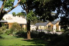
Barn Accommodation - Mount Gambier 
From: A$190 More Info... |
Kalangadoo Map
 Multiple Hotels
  Hotel
Hotel 

