Greens Beach Accommodation, Hotels, Tours & Information
Places nearby Greens Beach
- Alanvale
- Alberton
- Ansons Bay
- Apslawn
- Auburn
- Avoca
- Bacala
- Beaconsfield
- Beaumaris
- Beauty Point
- Beechford
- Bell Bay
- Bellingham
- Ben Lomond
- Binalong Bay
- Birralee
- Bishopsbourne
- Blackstone Heights
- Blackwall
- Blackwood Creek
- Blessington
- Blue Rocks
- Bracknell
- Branxholm
- Breadalbane
- Breona
- Bridgenorth
- Bridport
- Bronte Park
- Burns Creek
- Butlers Gorge
- Campbell Town
- Cape Barren Island
- Carrick
- Chain Of Lagoons
- Clarence Point
- Clarendon
- Cleveland
- Cluan
- Conara
- Cornwall
- Corra Linn
- Cressy
- Cuckoo
- Cullenswood
- Danbury Park
- Deddington
- Dee
- Delmont
- Deloraine
- Derby
- Deviot
- Devon Hills
- Diddleum Plains
- Dilston
- Douglas River
- Dunorlan
- East Launceston
- Elizabeth Town
- Elphin
- Emita
- English Town
- Epping Forest
- Evandale
- Exeter
- Exton
- Falmouth
- Fingal
- Flinders Island
- Flowery Gully
- Forester
- Four Mile Creek
- Frankford
- Franklin Village
- Frodsley
- George Town
- Gladstone
- Glendhu
- Glengarry
- Golconda
- Golden Valley
- Goshen
- Goulds Country
- Gravelly Beach
- Gray
- Grindelwald
- Hadspen
- Hagley
- Herrick
- Hillwood
- Hollow Tree
- Holwell
- Ilfraville
- Inveresk
- Invermay
- Jackeys Marsh
- Jetsonville
- Kamona
- Karoola
- Kayena
- Kelso
- Killiecrankie
- Kings Meadows
- Lackrana
- Lady Barron
- Lalla
- Lanena
- Launceston
- Launceston South
- Lebrina
- Lefroy
- Legana
- Legerwood
- Legunia
- Lietinna
- Liffey
- Lilydale
- Lisle
- Loccota
- Longford
- Lottah
- Low Head
- Lughrata
- Lulworth
- Mangana
- Mathinna
- Mayfield
- Meander
- Memana
- Miena
- Montana
- Moorina
- Mount Direction
- Mount Nicholas
- Mount William National Park
- Mowbray
- Mowbray Heights
- Musselboro
- Musselroe Bay
- Myrtle Bank
- Nabowla
- Needles
- Newnham
- Newstead
- Nile
- Norwood
- Notley Hills
- Nunamara
- Oaks
- Ormley
- Osmaston
- Osterley
- Palana
- Paper Beach
- Parkham
- Pateena
- Patersonia
- Perth
- Pioneer
- Pipe Clay Bay
- Pipers Brook
- Pipers River
- Poatina
- Powranna
- Priory
- Prospect
- Prospect Vale
- Punchbowl
- Pyengana
- Quamby Brook
- Ranga
- Ravenswood
- Red Hills
- Reedy Marsh
- Relbia
- Retreat
- Richmond Hill
- Ringarooma
- Riverside
- Robigana
- Rocherlea
- Roses Tier
- Rosevale
- Rosevears
- Rossarden
- Rowella
- Sandhill
- Scamander
- Scottsdale
- Selbourne
- Seymour
- Shannon
- Sidmouth
- South Mount Cameron
- St Helens
- St Leonards
- St Marys
- Steiglitz
- Steppes
- Storys Creek
- Strickland
- Summerhill
- Targa
- Tarraleah
- Tasmania North Central
- Tayene
- Telita
- Toiberry
- Tomahawk
- Tonganah
- Tower Hill
- Trenah
- Trevallyn
- Tulendeena
- Tullochgorum
- Tunnel
- Turners Marsh
- Underwood
- Upper Esk
- Victoria Valley
- Waddamana
- Warrentinna
- Waterhouse
- Waverley
- Wayatinah
- Weetah
- Weldborough
- West Launceston
- Westbury
- Western Junction
- Westwood
- Weymouth
- White Hills
- Whitemark
- Whitemore
- Wihareja
- Windemere
- Windermere
- Winkleigh
- Winnaleah
- Wyena
- York Town
- Youngtown
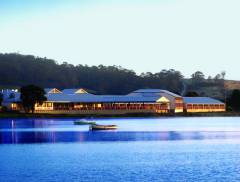
Greens Beach
Approximately 60 kilometres (37 miles) north-west of Launceston and at the mouth of the Tamar River lies Greens Beach, a take-off point for Narawntapu National Park. Narawntapu National Park has three access points at Bakers Beach, Badger Head and Greens Beach. The latter has to be the best reward for least effort; from the carpark it is an easy 270 metre (295 yard) walk to the West Head lookout for spectacular clifftop views along Badger Head beach and beyond westward as far as Table Cape and the Dial Ranges behind Ulverstone. Discover nearby Kelso Beach and enjoy a great spot for fishing. You can access Garden Island on Clarence Point, now a barren lookout point at the mouth of the Tamar River. It was excavated and backfilled towards the shore to improve the shipping channel in the river. There are plenty of oysters and good fishing here and it is also a scenic lookout.
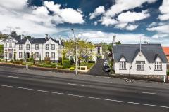
Great deals on hotels in Launceston/Nth East...
|
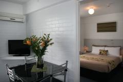
Adina Place Motel Apartments - Launceston 
From: A$206 More Info... |
|
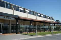
Bayside Hotel - St Helens 
From: A$173 More Info... |
|
Best Western Plus Launceston - Launceston   
From: A$208 More Info... |

|
Elphin Motel & Serviced Apartments - Launceston
From: A$175 More Info... |
|
Georges Bay Apartments - St Helens 
From: A$194 More Info... |

|
Hotel Verge Launceston - Launceston 
From: A$234 More Info... |
|
Nightcap at Riverside Hotel - Launceston
From: A$185 More Info... |
|
Panorama Hotel St Helens - St Helens
From: A$220 More Info... |
|
Quality Hotel Colonial Launceston - Launceston
From: A$179 More Info... |
|
Scamander Beach Resort - Scamander
From: A$163 More Info... |

Greens Beach


Greens Beach Map
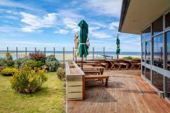
 Multiple Hotels
  Hotel
Hotel 

