Meekatharra Accommodation, Hotels, Tours & Information
Places nearby Meekatharra
- Ajana
- Arrino
- Badgingarra
- Beachlands
- Beacon
- Beresford
- Big Bell
- Binnu
- Binnu West
- Bluff Point
- Boogardie
- Boolardy
- Bootenal
- Bowgada
- Bunjil
- Canna
- Cape Burney
- Carnamah
- Caron
- Coolimba
- Coorow
- Cue
- Dongara
- Drummond Cove
- Eneabba
- Eneabba North
- Eradu
- Gascoyne Junction
- Georgina
- Geraldton
- Glenburgh
- Glenfield
- Green Head
- Greenough
- Gutha
- Horrocks
- Howatharra
- Hutt
- Indarra
- Irwin
- Isseka
- Jameson
- Jurien Bay
- Kalbarri
- Karloo
- Kojarena
- Koolanooka
- Latham
- Lawlers
- Leeman
- Leinster
- Lynton
- Mahomets Flats
- Marchagee
- Merkanooka
- Mingenew
- Moonyoonooka
- Morawa
- Moresby
- Mount Erin
- Mount Magnet
- Mount Narryer
- Mount Tarcoola
- Mullewa
- Murchison
- Murgoo
- Nabawa
- Nannine
- Nanson
- Naraling
- Narngulu
- Northampton
- Northern Gully
- Oakajee
- Oakbella
- Ogilvie
- Paynes Find
- Paynesville
- Perenjori
- Pindar
- Pintharuka
- Point Moore
- Port Denison
- Port Gregory
- Rangeway
- Reedy
- Regional West Australia
- Sandstone
- Snag Island
- Spalding
- Strathalbyn
- Sunset Beach
- Tarcoola Beach
- Tardun
- Tenindewa
- Three Springs
- Tuckanarra
- Utakarra
- Waddy Forest
- Waggrakine
- Walkaway
- Wandina
- Webberton
- West End
- Whelarra
- Wicherina
- Wilroy
- Wiluna
- Winchester
- Wongoondy
- Wonthella
- Wooree
- Woorree
- Wurarga
- Yalgoo
- Yandanooka
- Yeelirrie
- Youanmi
- Yuin
- Yuna
Meekatharra
Located approximately 500 kilometres inland from Geraldton, Meekatharra is the centre of a mining, sheep and cattle district. The area has many old worked out gold mines and old machinery relics. This old gold mining area abounds with remnants of its historical past. First settled by prospectors in 1896, mining still continues today on a small scale. A visit to the ghost towns of Peak Hill and Nannine is a must for the visitor, where the ruins and old mines can be explored. A new addition to Meekatharra's tourism attractions, the Meeka Rangelands Discovery Trail winds around Meekatharra Creek and includes a look out from which a モsuperpitヤ mine and the town of Meekatharra can be viewed. Interpretive signage along the trail features information relating to Meekatharra's Indigenous and settlement history. Visit the Royal Flying Doctor Service, enjoy a video presentation of the Royal Flying Doctor Service operation and you can listen to 'School of the Air'. The State Battery stands proudly along Meekatharra Creek with other interesting relics from Meekatharra's gold mining past. Visit the 25 Mile Well located 40 kilometres north of town on the Great Northern Highway. During 1976, the Meekatharra Lions Club restored the well as a tribute to the old drovers and stockmen who passed that way through the years. When the winter rains fall, the red earth around Meekatharra gives life to a dazzling array of colourful wildflowers. A must see for the fauna enthusiast. Look out for the red sturt pea and the signature flower of Meekatharra. And while you're on the lookout, emus, kangaroos, wedge tailed eagles and bungarra lizards are all prevalent in the area. An interesting rock formation, Peace Gorge, is just five kilometres from town off the Gascoyne Junction Road.
Great deals on hotels in Mid West...
|
Hospitality Geraldton, SureStay Collection by Best Western - Geraldton  
From: A$169 More Info... |

|
Kalbarri Edge Resort - Kalbarri  
From: A$199 More Info... |
|
Nesuto Geraldton Apartment Hotel - Geraldton 
From: A$270 More Info... |
|
The Gerald Apartment Hotel - Geraldton
From: A$282 More Info... |

Meekatharra
Meekatharra Map
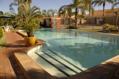
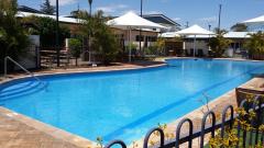
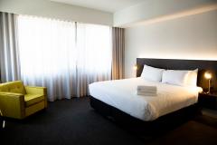
 Multiple Hotels
  Hotel
Hotel 

