Rosedale Accommodation, Hotels, Tours & Information
Places nearby Rosedale
- Aberfeldy
- Airly
- Alberton
- Allambee
- Allambee South
- Almurta
- Anderson
- Arawata
- Archies Creek
- Athlone
- Balook
- Barry Beach
- Bass
- Baw Baw
- Bayles
- Beardmore
- Bena
- Bennison
- Berrys Creek
- Binginwarri
- Blackwarry
- Blackwood Forest
- Boisdale
- Bonnie Brae
- Boolarong
- Boolarra
- Boys
- Brandy Creek
- Briagolong
- Budgeree East
- Buffalo
- Bull Swamp
- Buln Buln
- Bundalaguah
- Bunyip
- Bunyip North
- Burndale
- Bushy Park
- Caldermeade
- Callignee
- Calrossie
- Cape Paterson
- Cape Woolamai
- Cardinia
- Carmichael
- Carrajung
- Carrajung South
- Catani
- Cherrilong
- Childers
- Christies
- Churchill
- Cloverlea
- Clydebank
- Coalville
- Cobains
- Connors Plain
- Coongulla
- Coopers Creek
- Cora Lynn
- Corinella
- Coronet Bay
- Cowes
- Cowwarr
- Crossover
- Culloden
- Cypress Grove
- Dalmore
- Dalyston
- Darlimurla
- Darnum
- Darriman
- Dawson
- Delburn
- Denison
- Devon North
- Dollar
- Driffield
- Drouin
- Drouin East
- Drouin West
- Dudley South
- Dumbalk
- Dutson
- Ellerside
- Ellinbank
- Erica
- Fairbank
- Ferndale
- Fish Creek
- Flynn
- Flynns Creek
- Foster
- Foster North
- French Island
- Fulham
- Fumina
- Gaffneys Creek
- Gainsborough
- Garfield
- Gelliondale
- Giffard
- Giffard West
- Glen Alvie
- Glen Forbes
- Glengarry
- Glenmaggie
- Gormandale
- Grantville
- Greenmount
- Gunyah Gunyah
- Guthridge
- Hallora
- Hallston
- Harmers Haven
- Hazel Park
- Hazelwood North
- Heath Hill
- Hedley
- Hernes Oak
- Heyfield
- Hiamdale
- Hiawatha
- Hicksborough
- Hill End
- Hoddle
- Hunterston
- Icy Creek
- Inverloch
- Iona
- Jack River
- Jeeralang
- Jeetho
- Jericho
- Jindivick
- Jumbuk
- Jumbunna
- Kardella
- Kardella South
- Kernot
- Kilcunda
- Kilmany
- Kongwak
- Koo Wee Rup
- Koo-wee-rup
- Koonwarra
- Koornalla
- Korrine
- Korumburra
- Krowera
- Labertouche
- Lance Creek
- Lang Lang
- Lardner
- Le Roy
- Leongatha
- Licola
- Lillico
- Limonite
- Livingstone
- Llowalong
- Loch
- Loch Valley
- Longford
- Longwarry
- Longwarry North
- Macks Creek
- Madalya
- Maffra
- Manns Beach
- Mardan
- Maryknoll
- Matlock
- Mcloughlins Beach
- Meeniyan
- Mewburn Park
- Mirboo
- Mirboo East
- Mirboo North
- Modella
- Moe
- Moe-Yallourn
- Monomeith
- Montgomery
- Moondarra
- Morwell
- Morwell East
- Mount Baw Baw
- Mount Best
- Mount Eccles
- Mountain View
- Moyarra
- Mt Baw Baw
- Munro
- Myrtlebank
- Nambrok
- Narracan
- Nayook
- Neerim
- Neerim East
- Neerim Junction
- Neerim North
- Neerim South
- Nerrena
- Nerrena East
- Newborough
- Newborough East
- Newhaven
- Newry
- Nilma
- Noojee
- Nyora
- Outtrim
- Parkers Corner
- Perry Bridge
- Phillip Island
- Piedmont
- Poowong
- Port Albert
- Port Franklin
- Port Welshpool
- Pound Creek
- Powlett River
- Proctors
- Queensferry
- Ranceby
- Rawson
- Red Jacket
- Rhyll
- Ripplebrook
- Riverslea
- Robertsons Beach
- Robin Hood
- Rokeby
- Ruby
- Ryanston
- Ryton
- Sale
- Sale North
- Sale West
- San Remo
- Sandy Point
- Seaspray
- Seaton
- Seaview
- Shady Creek
- Smiths Beach
- St Helier
- Staceys Bridge
- Stockdale
- Stony Creek
- Stradbroke
- Stratford
- Strzelecki
- Tanjil Bren
- Tanjil South
- Tankerton
- Tarago
- Tarra Valley
- Tarraville
- Tarwin
- Tarwin East
- Tarwin Lower
- The Gurdies
- The Heart
- Thorpdale
- Thorpdale South
- Tidal River
- Tinamba
- Tonimbuk
- Toongabbie
- Toora
- Tooradin
- Topiram
- Trafalgar
- Traralgon
- Trida
- Turtons Creek
- Tyers
- Tyers Junction
- Upper Morwell
- Valencia Creek
- Valley View
- Ventnor
- Venus Bay
- Vervale
- Vesper
- Walhalla
- Walkerville
- Walkerville North
- Walkerville South
- Waratah Bay
- Waratah North
- Warragul
- Wattle Bank
- Welshpool
- West Creek
- Westbury
- Whitelaw
- Willow Grove
- Willung
- Willung South
- Wilsons Promontory
- Winnindoo
- Womerah
- Won Wron
- Wonga
- Wonthaggi
- Wonyip
- Woods Point
- Woodside
- Woodside Beach
- Woolamai
- Woolamai Waters
- Woorarra
- Woorarra West
- Wooreen
- Wurruk
- Yallourn North
- Yanakie
- Yannathan
- Yarragon
- Yarram
- Yinnar
Rosedale
Set on the banks of the Latrobe River, the Princes Highway town of Rosedale began as a strategic staging post on the coach route between Port Albert and Sale and remains a convenient launching pad for trips to south Gippsland, the Latrobe Valley and the Strzelecki Ranges.
The town occupies part of the Holey Plain grazing run owned by the Curlewis brothers and takes its name from Rosedale Station which was opened up in the mid 1840s by David Parry-Okeden and his wife Rosalie who bequeathed her name to the village.
It is a pleasant town with its share of historic buildings including the Mechanics Institute (1863) and St Mark's Church (1874). Nambrok, a brick mansion set on the crest of a hill a few kilometres to the east of Rosedale, was built for pastoralist John King, a grandson of the third Governor of NSW.
Rosedale is at the centre of a shire which embraces Ninety Mile Beach and Holey Plains State Park.
Great deals on hotels in Phillip Is./Gipps Sth...
|
Genesta House - Cowes  
From: A$288 More Info... |
|
Oak Tree Lodge - Rhyll 
From: A$454 More Info... |
|
Phillip Island Apartments - Cowes 
From: A$379 More Info... |
|
Prom Country Lodge - Foster 
From: A$266 More Info... |
|
Tallawarra Homestead - Tonimbuk 
From: A$315 More Info... |
|
The Waves Serviced Apartments - Cowes 
From: A$295 More Info... |
|
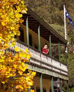
Walhalla's Star Hotel - Walhalla
From: A$340 More Info... |
Rosedale Map
 Multiple Hotels
  Hotel
Hotel 

