Emu Plains Accommodation, Hotels, Tours & Information
Places nearby Emu Plains
- Abbotsford
- Annandale
- Arndell Park
- Ashbury
- Ashcroft
- Ashfield
- Auburn
- Auburn North
- Auburn West
- Austral
- Badgerys Creek
- Bass Hill
- Belfield
- Belimbla Park
- Bella Vista
- Berala
- Bickley Vale
- Bidwill
- Birrong
- Blackett
- Blacktown
- Blairmount
- Blaxcell
- Bonnyrigg
- Bossley Park
- Bringelly
- Burwood
- Burwood Heights
- Burwood North
- Busby
- Cabarita
- Cabramatta West
- Cambridge Gardens
- Cambridge Park
- Camellia
- Campsie
- Canada Bay
- Canley Heights
- Canley Vale
- Carramar
- Cartwright
- Castlereagh
- Catherine Field
- Cecil Park
- Chester Hill
- Chipping Norton
- Chiswick
- Chullora
- Claremont Meadows
- Claymore
- Clyde
- Cobbitty
- Colebee
- Colyton
- Concord
- Concord North
- Concord West
- Condell Park
- Cranebrook
- Croydon
- Croydon Park
- Currans Hill
- Dean Park
- Dharruk
- Dobroyd Point
- Doonside
- Dundas
- Dundas Valley
- Dunheved
- East Hills
- Eastern Creek
- Edensor Park
- Edmondson
- Emerton
- Enfield
- Enfield South
- Ermington
- Erskine Park
- Erskineville
- Fairfield
- Fairfield Heights
- Fairfield West
- Five Dock
- Flemington
- Forest Lodge
- GINCBR
- Georges Hall
- Girraween
- Glebe Island
- Glebe Point
- Glendenning
- Glenmore Park
- Granville
- Green Valley
- Greenacre
- Greendale
- Greenfield Park
- Greystanes
- Guildford
- Guildford West
- Haberfield
- Harris Park
- Hassall Grove
- Hebersham
- Heckenberg
- Hewitt
- Hinchinbrook
- Homebush
- Homebush Bay
- Homebush West
- Homebush and Homebush Bay
- Horsley Park
- Huntingwood
- Hurlstone Park
- Ingleburn
- Jamisontown
- Kearns
- Kemps Creek
- Kentlyn
- Kings Langley
- Kings Park
- Kingswood
- Kingswood Park
- Lalor Park
- Leichhardt
- Leightonfield
- Lemongrove
- Leonay
- Lethbridge Park
- Lewisham
- Lidcombe
- Lidcombe North
- Lilyfield
- Liverpool South
- Llandilo
- Luddenham
- Lurnea
- Marayong
- Mays Hill
- Merrylands
- Merrylands West
- Miller
- Minchinbury
- Minto
- Mortlake
- Mount Annan
- Mount Druitt
- Mount Hunter
- Mount Lewis
- Mount Pritchard
- Mount Vernon
- Mulgoa
- Nelson
- North Rocks
- North Strathfield
- Northmead
- Oakhurst
- Oatlands
- Old Guildford
- Old Toongabbie
- Orangeville
- Orchard Hills
- Oxley Park
- Padstow
- Padstow Heights
- Panania
- Parklea
- Parramatta East
- Pendle Hill
- Penrith
- Penrith South
- Petersham
- Petersham North
- Plumpton
- Prairiewood
- Prospect
- Punchbowl
- Quakers Hill
- Raby
- Regentville
- Rhodes
- Rookwood
- Rooty Hill
- Rossmore
- Rouse Hill
- Russell Lea
- Rydalmere
- Sadlier
- Sefton
- Seven Hills
- Seven Hills West
- Shalvey
- Shanes Park
- Silverdale
- Silverwater
- Smithfield
- Smithfield West
- South Homebush
- South Strathfield
- Spring Creek
- St Clair
- St Johns Park
- St Marys
- St Marys East
- St Marys North
- St Marys South
- Stanmore
- Strathfield
- Strathfield North
- Strathfield South
- Strathfield West
- Summer Hill
- Sydney University
- Telopea
- Toongabbie
- Toongabbie East
- Tregear
- Villawood
- Wakeley
- Wallacia
- Wareemba
- Wentworthville South
- Werrington
- Werrington County
- Werrington Downs
- West Hoxton
- Westmead
- Wetherill Park
- Whalan
- Willmot
- Winston Hills
- Wisemans Ferry
- Woodcroft
- Woodpark
- Yagoona
- Yagoona West
- Yennora
Emu Plains
Emu Plains, New South Wales, Australia is located on the western side of the Nepean River, at the foot of the Blue Mountains. The suburb of Leonay is the southern boundary, with Emu Heights the western boundary. Along with the suburb of Penrith, Emu Plains is one of the oldest districts in the Penrith Local Government Area. It is situated in pleasant and peaceful surroundings enriched with the colour of jacaranda trees and autumn tones. Emu Plains has many historic buildings and sites to visit. Situated just five minutes drive from Penrith, Emu Plains is ideally located to all amenities. Emu Plains is located on the west side of the Nepean River extending to the foot of the Blue Mountains. Part of this name (i.e. 'Emu') is thought to have originated with the sighting of emus there when the country was first explored by Europeans in the late 1700's. A survey map of 26th August 1790 has the annotation 'saw three cassowaries' marked near the ford. Early explorers often confused emu with cassowary. The locality was first known as 'Emu Island' - the name thought to have originated with Captain Watkin Tench (1758?-1833), who first explored the region. In Government Orders of 16 July 1814, Governor Macquarie referred to 'Emu Plains (hitherto erroneously called Emu Island)', which officially heralded the area's change of name. And again in October 1814, George Suttor in his correspondence with Sir Joseph Banks, mentioned that the name Emu Plains had recently been changed from Emu Island. Up to this date the area had obviously been thought of as an island. The reason for this can possibly be explained by a contemporary observer, Barron Field (1786-1846), Judge of the Supreme Court of New South Wales. Field noted that Emu Plains had been called 'Emu Island' because the plains had, at times, been turned into an island by the 'washing of the mountains when the Nepean ......flooded'. Another more recent explanation (offered by the late local historian and resident Arthur W. Street) claims that the name Emu Island originated because the Nepean River was divided near Emu Ford, thus forming an island. The island, Mr. Street claims, has slowly disappeared through constant excavation of gravel for building purposes. A further resolution of the confusion is detailed in the book Emu Plains by Joan Steege, where she explores all the divergent theories regarding its naming. Governor Macquarie established a government farm at Emu Plains in 1819. Here convicts cleared the land and grew wheat, maize, tobacco and other crops for thirteen years. Land was not available for private settlement until the early 1830's, when a town named Emu was surveyed. On 25 October, 1963, the Emu Plains area was transferred from the Blue Mountains City Council to Penrith City Council.
Great deals on hotels in Sydney West...
|
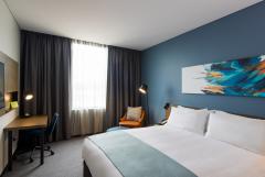
Holiday Inn St Marys - St Marys 
From: A$298 More Info... |
|
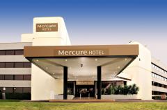
Mercure Penrith - Penrith 
From: A$279 More Info... |
Emu Plains Map
 Multiple Hotels
  Hotel
Hotel 

