Cohuna Accommodation, Hotels, Tours & Information
Places nearby Cohuna
- Angip
- Annuello
- Areegra
- Aubrey
- Bael Bael
- Baker
- Ballapur
- Bambill
- Bangerang
- Bannerton
- Banyan
- Baring
- Barrakee
- Batchica
- Bears Lagoon
- Beauchamp
- Benetook
- Benjeroop
- Berriwillock
- Beulah
- Beverford
- Billabong
- Bimbourie
- Birdwoodton
- Boigbeat
- Boinka
- Bolton
- Boolite
- Boorongie
- Borung
- Boulka
- Boundary Bend
- Brentwood
- Brim
- Broadford
- Bronzewing
- Broughton
- Buckrabanyule
- Budgerum
- Bulga
- Bullabul
- Bunguluke
- Burroin
- Cabarita
- Cal Lal
- Cannie
- Capels Crossing
- Cardross
- Carina
- Carron
- Carwarp
- Challambra
- Chillingollah
- Chinkapook
- Chirrup
- Cocamba
- Cokum
- Colignan
- Corack
- Cowangie
- Cramenton
- Crymelon
- Culfearne
- Culgoa
- Cullulleraine
- Curyo
- Danyo
- Dattuk
- Daytrap
- Dering
- Detpa
- Dinyarrak
- Donald
- Dooboobetic
- Dumosa
- Ellam
- Fairley
- Fairview
- Fernihurst
- Fiery Flat
- Fish Point
- Galah
- Galaquil
- Gama
- Gannawarra
- Glenloth
- Gonn Crossing
- Goongee
- Goschen
- Gowanford
- Goyura
- Hattah
- Haysdale
- Homecroft
- Hopetoun
- Hopevale
- Iraak
- Irymple
- Jarklin
- Jeffcott
- Jeparit
- Jil Jil
- Kalpienung
- Kangaroo Lake
- Kaniva
- Karadoc
- Karawinna
- Karween
- Kenley
- Kenmare
- Kerang
- Kiamal
- Kinnabulla
- Kinypanial South
- Koimbo
- Kooloonong
- Koondrook
- Koorkab
- Koorlong
- Korong Vale
- Koroop
- Korrak Korrak
- Kulwin
- Kunat
- Kurdgweechee
- Kurnwill
- Lah
- Lake Benetook
- Lake Boga
- Lake Buloke
- Lake Charm
- Lake Hindmarsh
- Lake Marmal
- Lalbert
- Larundel
- Lascelles
- Leeor
- Lillimur
- Lillimur South
- Linga
- Litchfield
- Long Plains
- Lorquon
- Macorna North
- Manangatang
- Massey
- Mcmillans
- Mead
- Meatian
- Mellis
- Melville Caves
- Merbein
- Merbein South
- Meringur
- Merrinee
- Mildura
- Mildura East
- Mildura South
- Mildura West
- Milnes Bridge
- Miralie
- Miram
- Mittyack
- Morkalla
- Morton Plains
- Mulcra
- Murrabit
- Murray Downs
- Murraydale
- Murrayville
- Myall
- Mysia
- Mystic Park
- Nandaly
- Nangiloc
- Narraport
- Narrewillock
- Narrung
- Natya
- Neds Corner
- Netherby
- Ngallo
- Nichols Point
- Ninda
- Nine Mile
- Ninyeunook
- Normanville
- Nowie North
- Nowingi
- Nullawil
- Nunga
- Nyah
- Nyah West
- Nyamville
- Nyarrin
- Nypo
- Oakvale
- Ouyen
- Patchewollock
- Pella
- Pental Island
- Peppers Plains
- Perenna
- Piangil
- Pier Millan
- Pine View
- Pira
- Pirlta
- Pompapiel
- Powlett Plains
- Prooinga
- Pullut
- Quambatook
- Rainbow
- Red Cliffs
- Reedy Dam
- Richmond Plains
- Robinvale
- Rosebery
- Rowland
- Rownack
- Sandhill Lake
- Sandsmere
- Sea Lake
- Serpentine
- Speed
- Speewa
- Stewart
- Sunnycliffs
- Sunset
- Swan Hill
- Swan Hill North
- Swan Hill Pioneer
- Tarrango
- Tarranyurk
- Teal Point
- Teddywaddy
- Telopea Downs
- Tempy
- Thalia
- Thurla
- Tiega
- Timberoo
- Timberoo South
- Tittybong
- Torrita
- Towaninny
- Tresco
- Tresco West
- Trinita
- Tudor
- Tunart
- Turriff
- Tutye
- Tyntynder Central
- Tyrrell Downs
- Ultima
- Underbool
- Vinifera
- Wagant
- Waitchie
- Walpeup
- Wargan
- Warne
- Warracknabeal
- Watchem
- Watchupga
- Wedderburn
- Wedderburn Junction
- Wemen
- Werrap
- Werrimull
- Westby
- Whirily
- Wilkur
- Wilkur South
- Willah
- Willangie
- Willenabrina
- Winlaton
- Winnambool
- Wood Wood
- Woomelang
- Woorinen
- Woorinen South
- Woornack
- Wooroonook
- Woosang
- Wychitella
- Wymlet
- Yaapeet
- Yanac
- Yarraby
- Yarrara
- Yarrock
- Yarto
- Yatpool
- Yearinga
- Yellangip
- Yelta
- Yeungroon
- Yungera
Cohuna
The Torrumbarry irrigation system has elevated Cohuna, 270 kilometres north of Melbourne, into a significant centre for surrounding dairy and pig farmers, beef, wool and timber producers.
The Murray Valley Highway town is adjacent to Gunbower Island, a flora and fauna sanctuary isolated by the Murray River and Gunbower Creek, which borders Cohuna.
The 50 kilometre long island is distinguished by swamps, billabongs, giant river red gums and box forests which are a haven for colonies of kangaroos, possums, emus, goannas and snakes and more than 160 different bird species. The island is networked by walking, riding and driving tracks, and has BBQ and picnicking facilities. Visitors can also take in the natural wonders on charter cruises on Gunbower Creek.
The region was thrust into the international anthropological spotlight in the late 1960s with the discovery in a Kow Swamp prehistoric burial site of human remains dating back 15,000 years. Those finds rekindled world interest in the origins of the first Australians, and subsequent research now indicates a continuous Aboriginal culture has existed for up to 70,000 years.
One of Cohuna's first churches, Scots Presbyterian, is now home to the District Historical Society whose collection includes part of a local tree marked by explorer Thomas Mitchell in 1836.
The town also boasts a second mirror into local history through the Mathers Waterwheel Museum, whose collection of memorabilia is complemented by an aviary of native birds.
Kow Swamp, which embraces the significant paleontologicial site of the same name, is a waterfowl sanctuary and a popular haunt of anglers.
Great deals on hotels in Murray Outback...

|
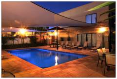
Best Western Chaffey International Motor Inn - Mildura 
From: A$189 More Info... |
|
Mercure Hotel Mildura - Mildura 
From: A$156 More Info... |
Cohuna Map
 Multiple Hotels
  Hotel
Hotel 

