Engadine Accommodation, Hotels, Tours & Information
Places nearby Engadine
- Alexandria
- Alfords Point
- Allawah
- Ambarvale
- Arncliffe
- Audley
- Bald Face
- Bangor
- Banksia
- Banksmeadow
- Bankstown
- Bankstown East
- Bankstown North
- Barden Ridge
- Bardwell Park
- Beaconsfield
- Belmore
- Belmore South
- Beverley Park
- Beverly Hills
- Bexley
- Bexley North
- Bexley South
- Blakehurst
- Bonnet Bay
- Botany
- Bow Bowing
- Bradbury
- Brighton-Le-Sands
- Brownlow Hill
- Bundeena
- Burraneer
- Buxton
- Camden
- Camden East
- Camden South
- Campbelltown
- Campbelltown North
- Camperdown
- Canterbury
- Caravan Head
- Caringbah
- Carlton
- Carss Park
- Chifley
- Clemton Park
- Como
- Como West
- Connells Point
- Couridjah
- Cronulla
- Daceyville
- Darlington
- Denham Court
- Dolans Bay
- Dolls Point
- Dulwich Hill
- Eagle Vale
- Earlwood
- Eastlakes
- Edmondson Park
- Ellis Lane
- Enmore
- Eschol Park
- Gilead
- Glen Alpine
- Glenfield
- Glenlee
- Glenmore
- Grasmere
- Grays Point
- Gymea
- Gymea Bay
- Hammondville
- Harrington Park
- Heathcote
- Hillsdale
- Holsworthy
- Hurstville
- Hurstville Grove
- Hurstville South
- Illawong
- Jannali
- Kangaroo Point
- Kareela
- Kingsford
- Kingsgrove
- Kingsway West
- Kirkham
- Kirrawee
- Kogarah
- Kogarah Bay
- Kurnell
- Kyeemagh
- Kyle Bay
- La Perouse
- Lakemba
- Lakemba South
- Lakesland
- Leppington
- Leumeah
- Lilli Pilli
- Little Bay
- Loftus
- Lucas Heights
- Lugarno
- Lugarno North
- Lurline Bay
- Macquarie Fields
- Maianbar
- Malabar
- Manly West
- Maroubra
- Maroubra Bay
- Maroubra Junction
- Maroubra South
- Marrickville
- Marrickville South
- Marrickville West
- Mascot
- Matraville
- Menai
- Menangle
- Menangle Park
- Milperra
- Minto Heights
- Miranda
- Monterey
- Moorebank
- Mortdale
- Mowbray Park
- Narellan
- Narellan Vale
- Narwee
- Nattai
- Nattai River
- Newtown
- Oakdale
- Oatley
- Oatley West
- Oyster Bay
- Pagewood
- Peakhurst
- Peakhurst South
- Penshurst
- Phillip Bay
- Picnic Point
- Picton
- Pleasure Point
- Port Botany
- Port Hacking
- Ramsgate
- Razorback
- Regents Park
- Revesby
- Revesby Heights
- Revesby North
- Riverwood
- Rockdale
- Rosebery
- Roselands
- Rosemeadow
- Royal National Park
- Ruse
- Sandringham
- Sandy Point
- Sans Souci
- Smeaton Grange
- South Belmore
- St Andrews
- St Helens Park
- St Peters
- Sutherland
- Sydenham
- Sydney Airport
- Sylvania
- Sylvania Waters
- Tahmoor
- Taren Point
- Tempe
- The Oaks
- Theresa Park
- Thirlmere
- Turrella
- Undercliffe
- Varroville
- Voyager Point
- Warumbul
- Waterloo
- Wattle Grove
- Wedderburn
- Werombi
- Wiley Park
- Wolli Creek
- Woodbine
- Woolooware
- Woronora
- Woronora Heights
- Yarrawarrah
- Yowie Bay
- Zetland
Engadine
A Sutherland Shire suburb on Sydney's southern fringe, Engadine is sandwiched between the Woronora River and the Royal National Park, the first park to be declared in Australia.
The Royal embraces more than 16,000ha of sandstone plateau that opens on to several fine surf beaches of which Wattamolla and Garie are the best known, while the bayside beaches bordering Port Hacking are popular swimming and fishing spots.
The park is virtually bisected by the Hacking River and boats can be hired at Audley to capture a water perspective of the park which has recovered magnificently from the ravages of the disastrous 1994 bush fires.
Engadine"s northern border is defined by the Woronora River which also separates the suburb from the Australian Atomic Energy Research Establishment at Lucas Heights.
Controversy has long surrounded the AAER"s complex and the debate over whether Australia needs its own atomic energy research unit is back on the table as proposals to update the facility are back on the Commonwealth Government"s agenda.
Great deals on hotels in Sydney South and Airport...
|
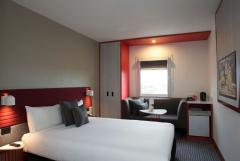
Best Western Plus Camperdown Suites - Camperdown 
From: A$196 More Info... |
|
ibis Sydney Airport - Mascot 
From: A$149 More Info... |
|
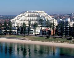
Novotel Sydney Brighton Beach - Brighton-Le-Sands 
From: A$288 More Info... |
|
Novotel Sydney International Airport - Wolli Creek 
From: A$219 More Info... |
|
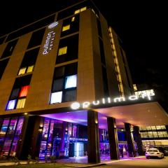
Pullman Sydney Airport - Mascot 
From: A$268 More Info... |
Engadine Map
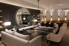
 Multiple Hotels
  Hotel
Hotel 

