Riverwood Accommodation, Hotels, Tours & Information
Places nearby Riverwood
- Alexandria
- Alfords Point
- Allawah
- Ambarvale
- Arncliffe
- Audley
- Bald Face
- Bangor
- Banksia
- Banksmeadow
- Bankstown
- Bankstown East
- Bankstown North
- Barden Ridge
- Bardwell Park
- Beaconsfield
- Belmore
- Belmore South
- Beverley Park
- Beverly Hills
- Bexley
- Bexley North
- Bexley South
- Blakehurst
- Bonnet Bay
- Botany
- Bow Bowing
- Bradbury
- Brighton-Le-Sands
- Brownlow Hill
- Bundeena
- Burraneer
- Buxton
- Camden
- Camden East
- Camden South
- Campbelltown
- Campbelltown North
- Camperdown
- Canterbury
- Caravan Head
- Caringbah
- Carlton
- Carss Park
- Chifley
- Clemton Park
- Como
- Como West
- Connells Point
- Couridjah
- Cronulla
- Daceyville
- Darlington
- Denham Court
- Dolans Bay
- Dolls Point
- Dulwich Hill
- Eagle Vale
- Earlwood
- Eastlakes
- Edmondson Park
- Ellis Lane
- Engadine
- Enmore
- Eschol Park
- Gilead
- Glen Alpine
- Glenfield
- Glenlee
- Glenmore
- Grasmere
- Grays Point
- Gymea
- Gymea Bay
- Hammondville
- Harrington Park
- Heathcote
- Hillsdale
- Holsworthy
- Hurstville
- Hurstville Grove
- Hurstville South
- Illawong
- Jannali
- Kangaroo Point
- Kareela
- Kingsford
- Kingsgrove
- Kingsway West
- Kirkham
- Kirrawee
- Kogarah
- Kogarah Bay
- Kurnell
- Kyeemagh
- Kyle Bay
- La Perouse
- Lakemba
- Lakemba South
- Lakesland
- Leppington
- Leumeah
- Lilli Pilli
- Little Bay
- Loftus
- Lucas Heights
- Lugarno
- Lugarno North
- Lurline Bay
- Macquarie Fields
- Maianbar
- Malabar
- Manly West
- Maroubra
- Maroubra Bay
- Maroubra Junction
- Maroubra South
- Marrickville
- Marrickville South
- Marrickville West
- Mascot
- Matraville
- Menai
- Menangle
- Menangle Park
- Milperra
- Minto Heights
- Miranda
- Monterey
- Moorebank
- Mortdale
- Mowbray Park
- Narellan
- Narellan Vale
- Narwee
- Nattai
- Nattai River
- Newtown
- Oakdale
- Oatley
- Oatley West
- Oyster Bay
- Pagewood
- Peakhurst
- Peakhurst South
- Penshurst
- Phillip Bay
- Picnic Point
- Picton
- Pleasure Point
- Port Botany
- Port Hacking
- Ramsgate
- Razorback
- Regents Park
- Revesby
- Revesby Heights
- Revesby North
- Rockdale
- Rosebery
- Roselands
- Rosemeadow
- Royal National Park
- Ruse
- Sandringham
- Sandy Point
- Sans Souci
- Smeaton Grange
- South Belmore
- St Andrews
- St Helens Park
- St Peters
- Sutherland
- Sydenham
- Sydney Airport
- Sylvania
- Sylvania Waters
- Tahmoor
- Taren Point
- Tempe
- The Oaks
- Theresa Park
- Thirlmere
- Turrella
- Undercliffe
- Varroville
- Voyager Point
- Warumbul
- Waterloo
- Wattle Grove
- Wedderburn
- Werombi
- Wiley Park
- Wolli Creek
- Woodbine
- Woolooware
- Woronora
- Woronora Heights
- Yarrawarrah
- Yowie Bay
- Zetland
Riverwood
About 30km south-west of Sydney's CBD, Riverwood evolved from a market gardening and small farming community into a residential area when the NSW Housing Commission took over 236ac in the 1950s. In 1942, the $1million 118th General Hospital was built for the US Army - the largest military hospital in Australia. There were 490 timber barracks-type buildings know as 'huts' built at the site, accommodating 1250 patients and 3500 staff in segregated, black and white quarters.. Immediately after the war, when the hospital reverted to the NSW Housing Commission, the huts were used to ease the chronic housing shortage. Riverwood is fortunate to have the broad Salt Pan Creek as its western boundary. This creek, which empties into the Georges River, which, in turn, finishes its course in Botany Bay, has kept generations of Riverwood's local children amused, fishing, boating and swimming. The creek gives local boaties direct access to the sea via the Georges River and Botany Bay.
Great deals on hotels in Sydney South and Airport...
|
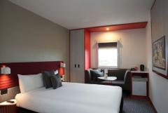
Best Western Plus Camperdown Suites - Camperdown 
From: A$201 More Info... |
|
ibis Sydney Airport - Mascot 
From: A$187 More Info... |
|
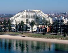
Novotel Sydney Brighton Beach - Brighton-Le-Sands 
From: A$316 More Info... |
|
Novotel Sydney International Airport - Wolli Creek 
From: A$228 More Info... |
|
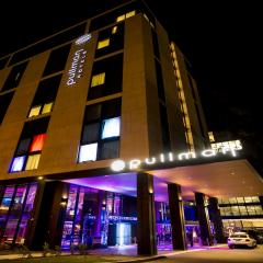
Pullman Sydney Airport - Mascot 
From: A$269 More Info... |
Riverwood Map
 Multiple Hotels
  Hotel
Hotel 

